If you thought Google Street View or Google Earth was the ultimate way to see the world sitting at your desk, you should check out Microsoft’s new web app.
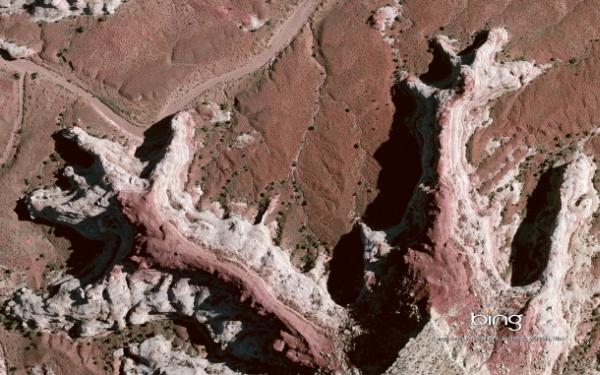
It aims to showcase the U.S. and Western Europe in high resolution images that would be mapped aerially. The new web app already features 153 spots around the United States, and is part of Microsoft’s Bing Maps Global Ortho project. The idea is to create a high-resolution, seamless mapping mosaic of the world one day which would not only make you admire the place you want to visit, but also be wonder-struck about how symmetric and artistic the world really seems, when seen from up above.
Microsoft is spending more than $100 million for the project and has already roped in pilots to fly aircrafts that are equipped with special cameras that cost more than $1 million each. These $1 million cameras capture images from the flying aircraft every few seconds. Each pixel equals to 6 inches but not more than 12 inches on the ground. The project is not about just taking pictures of the world and compili9ng them, and uploading them on a web app, but Microsoft also does the quality control of the images itself. Microsoft aims to create a mosaic of the world where in the images are free of smoke, cloud, non-permanent snow and even ‘standing water’.
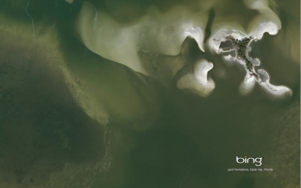
Users would be able to smoothly scroll across various regions of the world without even realizing that they are actually shifting from one image to the next one. Most current efforts at mapping by both Google and Microsoft reveal clearer pictures of urban areas, but this project aims to aerially map the countryside and rolling landscapes as well. United States and Western Europe shall be mapped by the end of this month and the rest of the world would follow.
Microsoft may not gain much revenue from this project, and may actually lose a lot of money in a very expensive project but then again these images have convinced most people that the project would result in aerial images of the world that would almost amount to abstract art. You could meanwhile read about Flex Touchscreen, which give you an elastic look at Google Maps. You can also read about how Google Maps tells you if your bus is going to be late.


